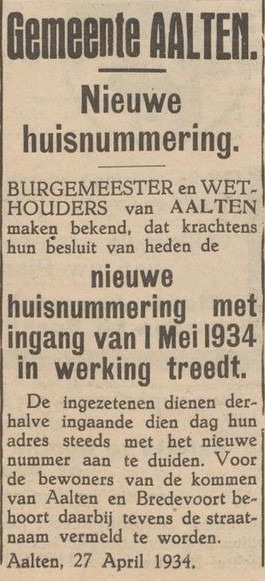
The addresses as we know them today, consisting of a street name and house number, were introduced in the built-up areas of Aalten and Bredevoort in 1934. The rural districts followed in 1967. Prior to that, since the early 19th century, every address had only a number, for example ‘Aalten 642’ or ‘Dale 21’. Furthermore, since the early 20th century, house numbers in the Aalten town centre were preceded by a letter.
Until the introduction of the current addresses, house numbers were regularly adjusted over the past two centuries due to the growing number of dwellings. In the household registers from 1823–1850, each household is listed by settlement/district and by dwelling, including the house number and – in the rural districts – the house name. Unfortunately, in the subsequent periods, the house name is no longer included.
By comparing household registers from different periods and ‘tracking’ the (successive) residents, as it were, from one period to the next, we have attempted to trace the changes in house numbering up to the point when the current addresses were introduced.
Via the ‘House Numbering’ menu above, you can view the number changes per town/district in tables, insofar as they have been identified and are known. The Aalten address books from 1934 and 1967 are also very useful in this regard. In some cases, however, it remains a tricky puzzle, and it is therefore inevitable that there are still errors here and there, partly because some addresses/house numbers were also changed after 1934/1967, for example due to the construction of new streets and roads.
In short: this is a work in progress!
House numbering per village / rural district
Example household register
An example of a household register from the period 1823–1850 for the Neerhof farm, formerly known as Dale 20:
